Tag: Derbyshire

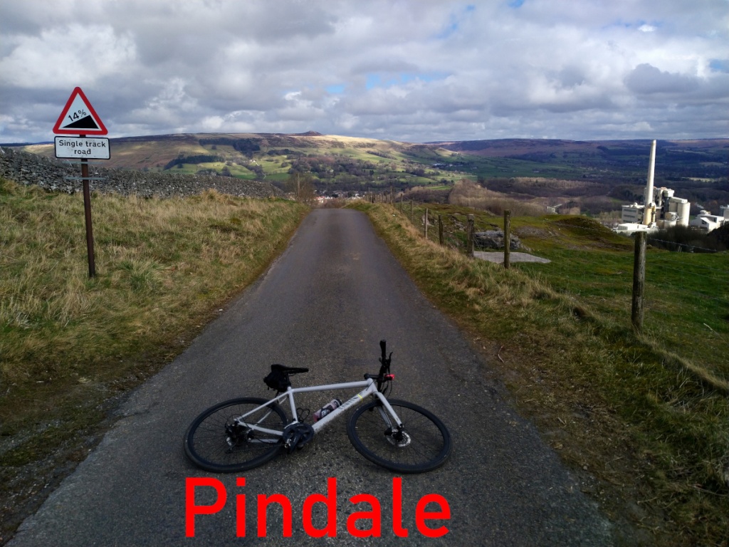
Pindale

  • Pindale
  • Length: 2.45 miles
  • Avg gradient: 5.9% (although it’s 10.5% if you start at the switchback)
  • Peak gradient: 17.5%
  • Difficulty: 4/5
  • Likelihood of encountering unpleasant motor-vehicles: 1/5
  • Elevation gain: 772ft
  • Strava

Hard as cement.

As you travel around the Hope Valley you can’t escape the extraordinarily ugly cement works that sit, like a festering scar, bang in the middle of the valley. How they ever got beyond planning permission, is a mystery. However, there is a lively, little known climb that snakes around the works’ back that makes it worth venturing over there.

Most of the segments around here commence in Castleton but it seems more appropriate somehow to start at the entrance to the cement works themselves. It’s a very gentle start as you leave the industrial monstrosity behind, along a singletrack road with a beautiful view of the Hope Valley and past a campsite. The gradient is creeping up from 5% to about 10% as you take the first sweeping bend to the right and the road surface starts to worsen.

Around the corner and you’re into low-medium double figures as the climb begins and the valley opens up below you. After about 300 metres of climb, however, the road drops away into a speedy descent but take care as the surface is awful and also probably covered in detritus.

When you reach the junction, take the sharp left up the hill, through the tree-tunnel, where the climb really begins. It’s pretty much straight into a 20% incline for about 300 metres before a short level-off as the road bends left. Recharge and prepare for the jewel in this climb: the sweeping bend as the trees drop away and the expansive vista of the Hope Valley opens below you, right in the middle of which is the pig-ugly, brutalist cement works. I’ve got different readings but I think the incline around the corner is about 15% but totally worth it. As you switchback, take a moment to enjoy the sight of Mam Tor and Loose Hill in the distance, but don’t forget that you’re far from done with the climb.

As the gradient drops to a more manageable 5% it may look like you’re approaching the top, but it’s just the first of a couple of false summits before the end. There’s a slight increase in steepness as you wiggle up the road, but nothing that feels insurmountable and it is now more of a psychological battle, as, having tackled the hardest section, the pesky hill just keeps going at 8%, with no end in sight.

It continues in this vain for about 3/4 of a mile, across exposed exposed moorland, skirting the top of the cement works quarry, before, finally, finally, you reach the top, marked by a drystone wall line and what was presumably, once a gate.

New Road

  • New Road
  • Length: 1.57 miles
  • Avg gradient: 5.1%   Peak gradient: 10.5%
  • Difficulty: 3/5
  • Likelihood of encountering unpleasant motor-vehicles: 2/5
  • Elevation gain: 419ft
  • Strava

A beautiful Derbyshire climb.

If you’ve been out in the Hope Valley, but don’t fancy tackling Fiddler’s Elbow, Surprise View or The Dale on your return to Sheffield, the best option to get up over that big hill between you and the city is probably New Road, near Bamford.

Just south of Ladybower Reservoir you’ll find this rather picturesque climb that is never too hard but also never easy. As you turn off Ashopton Road, you’re straight into a 9% climb, so it’s heads down from the off. The gradient fluctuates between 5 – 10% for the next mile or so as you ascend the tree lined road. On your left, you’re presented with the imposing sight of Bamford Moor and, on your right, the view across the valley towards Thornhill and Shatton, the vista improving steadily as you make your way up New Road.

It’s a fairly straight line, with the biggest hazard being gangs of walkers or motorists descending a bit too quickly but it’s usually a relatively quiet ascent. One of the highlights happens around the 0.7 mile mark when, suddenly, the trees on your right drop away to reveal a most spectacular panorama across the valley. In the distance you might spy Shatton Mast, sitting atop Shatton Moor, the climb up to which I’d rate as a 5/5 (but we’ll save that for a later date).

The gradient sits around 5% here, so keep enjoying the view until you meet another line of trees and the road bends round to the left at what feels like its steepest section. You’ll shortly reach a summit, where there will likely be a few cars parked by local hikers, but you’re not at the end of the climb yet. The hill drops away into a fun and welcome descent but do take care, especially on the sharp right-hand bend which descends at -9%.


Try to keep your momentum here, as the gradient returns to almost 10% (but can feel greater), and you’ll soon reach the apex, where you’re greeted with a bench to sit on and one of the most beautiful views in the area.

Curbar Edge

  • Length: 1.1 miles
  • Avg gradient: 10%   Peak gradient: 15.2%
  • Difficulty: 4/5
  • Likelihood of encountering unpleasant motor-vehicles: 1/5
  • Elevation gain: 598 ft
  • Strava

There is pretty much nothing that I can say about Curbar Edge that hasn’t already been said in greater detail and with more authority elsewhere, not least Simon Warren’s 100 Greatest Cycling Climbs and James Allen’s 50 Classic Cycle Climbs but as it is what I’d consider a headline hill, it would be remiss of me to not include it here.

I’d driven up to Curbar Gap many times before, heading for family walks along the edge, so I was familiar with the hill, its two sweeping bends and the towering gritstone rocks that give the hill its character. It’s an even more impressive climb when you’re on a bike.

You start in the village of Curbar itself, next to All Saint’s Church, and it’s from here that you head up the innocuous looking Curbar Lane. As you pass The Old Vicarage on your right, the gradient is immediately into double figures, reaching 14.5% as the road bends to the right. This is the steepest section of the whole climb, which is a good thought to keep in mind as you progress up the hill, eventually passing a red telephone box at a crossroads.

The climb now drops to a more pleasant 6-7% for a straight section, lined with rather nice looking houses with big gardens. You’ve pretty much reached the halfway mark when you pass the national speed limit sign, which sees the gradient return to around 10-11% and, more impressively, the countryside open up and the appearance of Curbar Edge, loom ominously above you.

The steepness remains fairly consistent around the first sweeping bend and then reaches 11.5% as you head towards the second, sharper corner. The views from here more than make up for the additional challenge though. Just try not to focus on the ridge of Curbar Gap which, at this point, still seems very high up and very far away.

Grind on around the next bend and, once you’ve passed a gate into a field on your right, I always feel like you’re pretty much there. You still have to cycle 0.3 miles and climb 130 ft but it’s broadly straight with a gradient of less than 10% and the views alone will keep your legs powered until you reach the car park at the peak.

Curbar Edge is a beautiful climb worth travelling for.