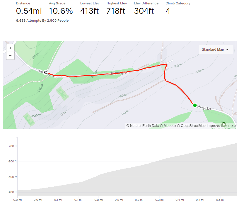
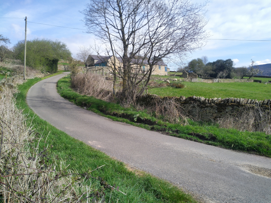
Turning off the main road though Baslow, you join Bubnell Lane after crossing the river, and before you reach the beginning of this picturesque climb, you’re gifted a pleasant totter alongside the Derwent. Not long after the river meanders away from the road, you’ll reach the start of the climb, marked by a gate on your left and, up the hill, a farmhouse and stables.
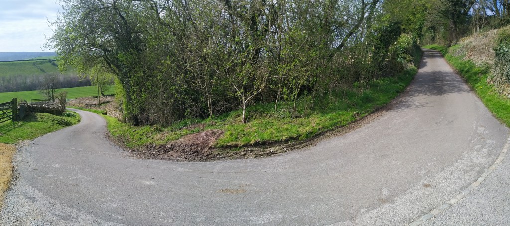
Within the first 0.1 mile, you’re hitting around 8% but you will feel the extra 2% as you ride around the bend in the road. You’ll shortly reach the stables and the switchback: at 17.7%, the steepest section of the climb. It’s a quiet road, so fairly safe to go wide and take a shallower line.
From here, it’s a steady, straight plod to the top, graced by trees on your right and a lovely Derbyshire vista on your left. The gradient fluctuates around 10%, so it’s never too challenging, it just seems long because the top is hidden just around that corner you can see in the distance.
Once you make it round the corner, the top is marked by a footpath post, followed by a speedy descent to Hassop Road and down to Calver.
Pea Royd Lane is a fairly well known road, having been used for many hill climb races including the National Championships, so I’m sure there are far more authoritative and informative descriptions of this notorious cycle elsewhere on the internet but, since you’re here, make yourself comfortable.
This climb begins before you even get to the start of Pea Royd Lane, requiring you to cycle for 0.2 miles up Hunshelf Road, at a not insignificant 7.7% average. Once you’re past the factories and the view begins to open out over Stocksbridge, you’ll see Croft House on your left and a switchback on your right: the beginning of Pea Royd Lane proper.
In Simon Warren’s 100 Greatest Cycling Climbs he says ‘the surface is terrible and gets worse’ but I think the road must have been resurfaced since then as it’s not too bad now, not that that makes the road any less steep. This section, up to the bridge, involves some of the steepest climbing, with the incline hovering around the upper teens, briefly breaking 20%.
You’re given a short relent crossing the bridge but the hill is soon back to 15-16% on the approach to the next switchback. Take the bend as wide as you can (it is a quiet road but it’s not devoid of all traffic) and grab a look over your shoulder to appreciate how high you have come out of Stocksbridge. You’re now climbing at around 13-14% for 100 metres or so but this is the part I always find hardest as the end is still hiding from view.
The road shallows slightly as you pass a farm before picking right back up as you finally approach the apex, signified by black rocks jutting out of the hillside and which is hiding just around the corner.
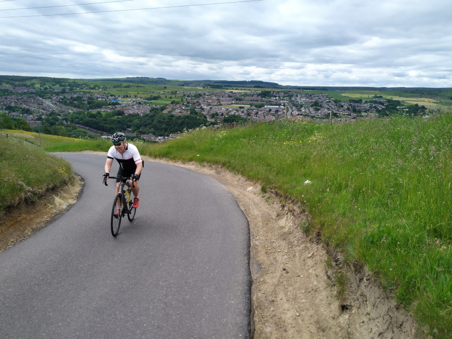
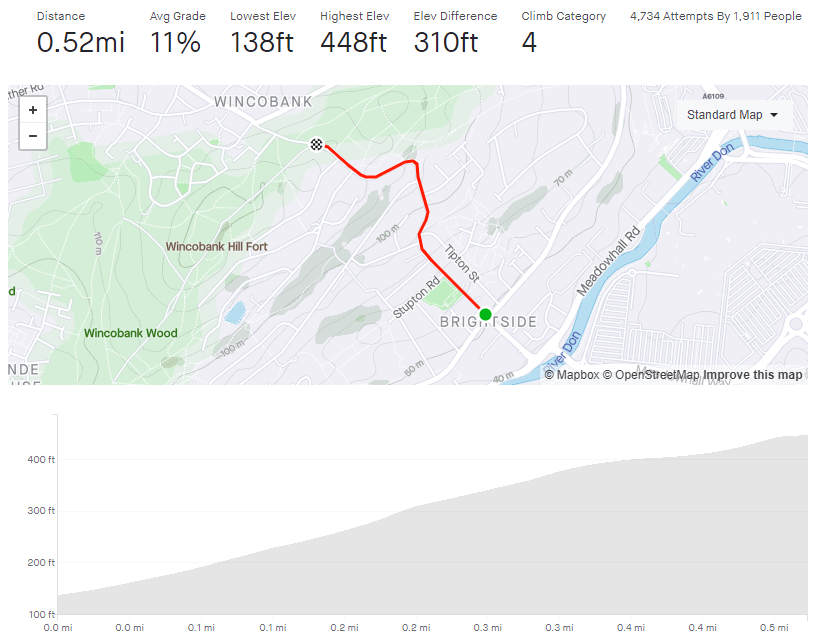
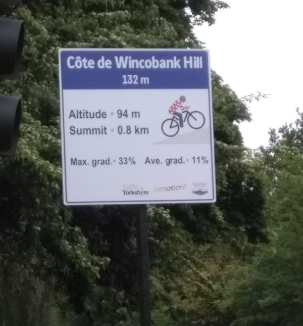
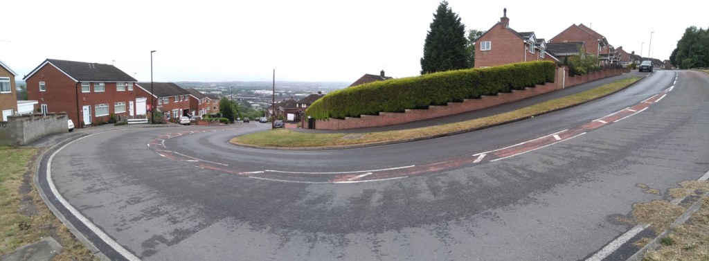
Many of Sheffield’s hills are fairly anonymous, some have a little local notoriety and some have enough of a reputation to feature in the Tour de France. Jenkin Road (or the Côte de Wincobank Hill as it was renamed for The Grande Départ in 2014) is one of those hills.
As a result of its reputation, I’d been putting off attempting this climb for some time but finally relented during lockdown, figuring that I’d be delaying fewer cars as I plodded upwards. The fact that I do every climb at least twice (once to do the climb and a second time to take photos) just added to the trepidation.
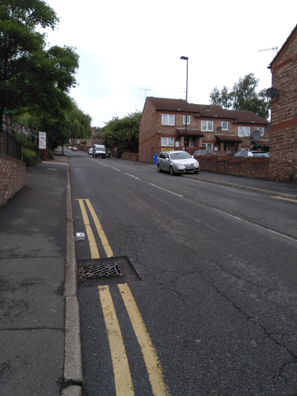
Starting from the junction with Holywell Road, you’re already at a disadvantage, having had to stop at the crossroads and therefore beginning from a standing start. It’s here that the sign, commemorating Jenkin Road’s role in the 2014 Tour, is placed. It states that the average gradient is a perfectly acceptable 11% but the maximum gradient is a formidable 33%. I think that’s an exaggeration and Strava and Veloviewer both agree, putting the peak gradient closer to 16.8%. Jenkin Road’s steepest segment is slightly wiggly, so maybe in a straight line it’s closer to 33%.
The hill begins at a fairly standard 10% as it stretches ahead of of you. With houses, playing fields and a church, there’s not much yet to mark this climb as distinct from the likes of Mertyle Road but, just after you pass the church, the road curves to the right, the gradient ramps up and, ahead of you, you can see why the hill made it into the Tour.
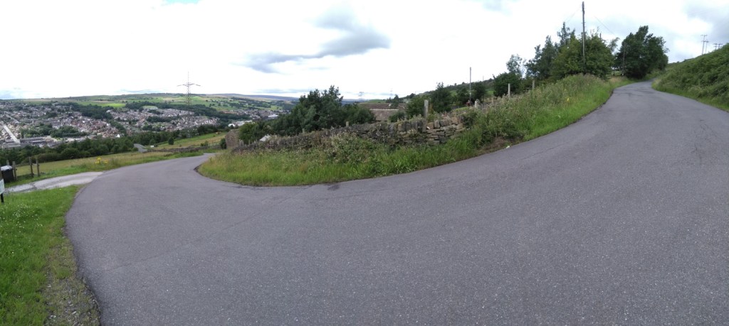
The road turns into a little S-bend here and the gradient hits 17.2% as it wiggles back and forth. Do your best here and don’t worry too much about any vehicles behind you, they’re as likely struggling up as much as you. As the hill relents a bit, down to about 12% as you pass Ridge View Road on your right, take a moment to regain a bit of strength (and have a look at the view behind you if you can) because you only about half way there.
You’ll shortly reach a sweeping switchback, which starts easily enough but its a bit deceptive and you’ll notice the extra couple of percentage points on the gradient here. However, once you’re round the bend with Wincobank Common on your right, it’s the home stretch, even dropping down to a meagre 4.5% around the next corner. Once you’ve done that, you can see the final 9.5% hump approaching and shortly you’ll be at the top. Well done.
You can see the pros on the 2014 Tour, climbing up the wiggly bit, below.
Now go and put on your yellow jersey and pretend you’ve just won the Tour De France.
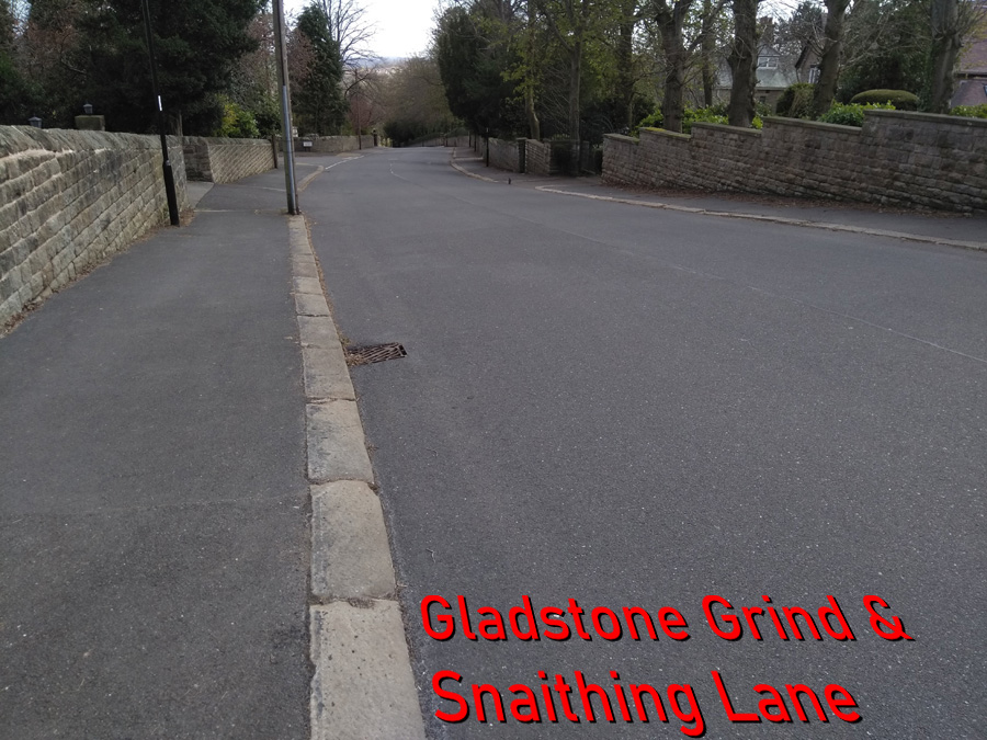
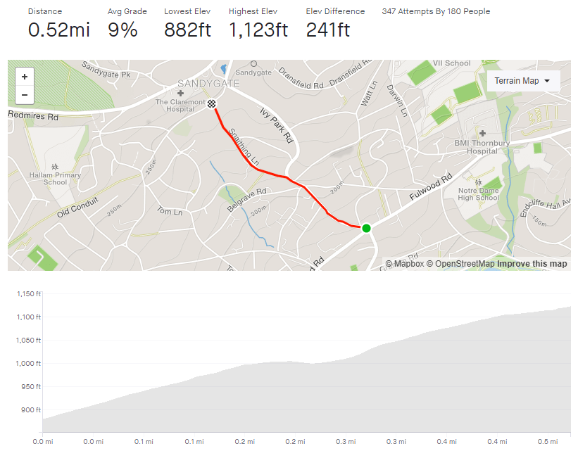
Starting and finishing in similar locations and running fairly parallel to each other, the Gladstone Grind / Snaithing Lane climb is similar to – but easier than – Tom Lane. They’re both suitable tasters for some of the hills in the Peak District that these roads lead you towards.
Begin at the crossroads with Fulwood Road (the segment could begin at the bottom of Hangingwater Road but I’ve never managed to reach this crossroads without the lights turning red) and the hill is straight into double figures, hovering around the 11% mark. It’s a tree-lined road with a broad right hand curve that seems to stretch on and on. If you’re lucky, the yappy dog at number seven will come charging down the driveway at you but he’s stuck behind a gate, so you can pedal on safely.
Shortly after the road straightens out, Graham Road joins from the left. It’s heads down here and grind on as I find that there is something about this section that feels a real slog. It’s probably as it’s just a straight 10% line, with just a postbox near the crest to aim for.
A short distance past the postbox, you’re gifted a very brief downhill as you swing left off Gladstone Road, onto Snaithing Lane. The 2020 Magnificent 7 race continued up Ivy Park Road at this point but I think Snaithing Lane is a more interesting challenge, so stick with that. The downhill respite is short lived however, as the road spikes up and bends to the right. As you pass the Kings Foundation, you’re on the steepest section of the hill at around 13.5%, but it does feel steeper.
You’ll soon pass a large white house with a fancy balcony, on your right. That’s the sign that you’re over the worst, and the road drops to a more manageable 7% for the final 0.1 mile. Once you’ve reached the top, if you fancy an additional silly little challenge, turn left, then take the first right up Carsick View Road. A cheeky little spike that was not quite close enough to include as part of this entry.
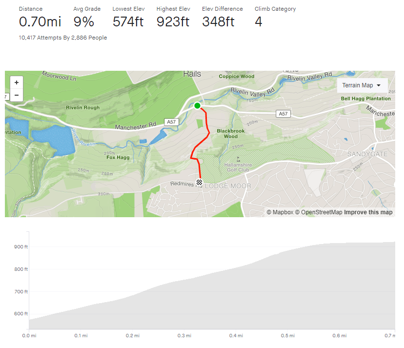
A few miles westward, out of the city, along the fairy nasty A57 Manchester Road you’ll find a couple of cheeky challenging climbs, escalating either side of the Rivelin Valley: Rails Road and Lodge Lane. Rails Road will take you north up to Stannington, and Lodge Lane, south, to the green and pleasant lands of Lodge Moor.
Like many of the roads that climb the Rivelin valley wall (see also: Hagg Hill), unless you’re lucky with oncoming traffic, you’re pretty much going to lose all of your momentum turning 90 degrees onto the hill. Lodge Lane isn’t quite as a brutal start as Hagg Hill but you are straight into a 10% incline and a sharp left corner to begin. The steepness gradually increases as you follow the road round a right-hand bend and are presented with a straight stretch open in front of you.
As you pass the campsite, the incline drops to around 7%, which feels comparatively flat, so use this section to ease off a bit before you prepare to dig in again. As the road heads to the next bend the gradient is back in double figures and although it’s only 0.1 mile I find this part tough because I know what’s around the next corner. Since you’re now well above the valley with some lovely views towards the Peaks, it’s tempting to think you’re almost at the top. You are not.
As the tree line returns and you round the next bend, I always expect to see the top of the hill, when all Lodge Lane offers you is more of the same. In the distance, it’s not the end of the hill you can see but, at 15%, the hardest of the climb’s numerous bends. If you get round that, once you reach the roadside bollards you’ve made it and just need to pant on a few more feet to the end.
Now turn around, drop down at speed, and tackle Rails Road on the other side of the valley.