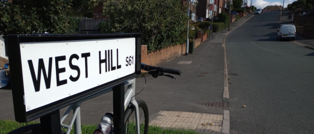
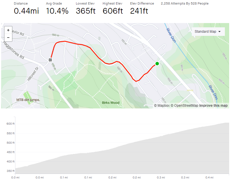
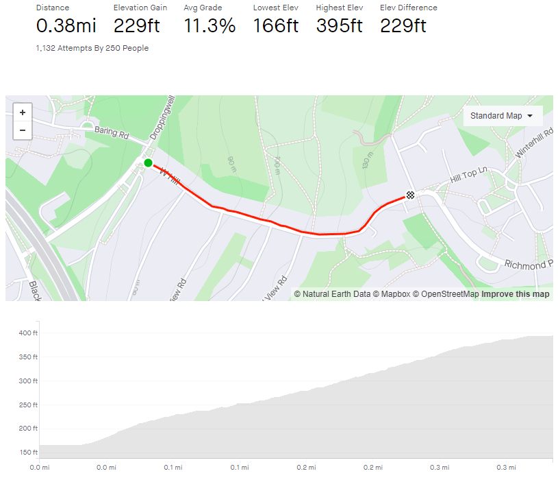
Tag: 2/5

West Hill

  • West Hill
  • Length: 0.38 miles
  • Avg gradient: 11.3%
  • Peak gradient: 24.2%
  • Difficulty: 2/5
  • Likelihood of encountering unpleasant motor-vehicles: 1/5
  • Elevation gain: 229ft
  • Strava

230 metres outside Sheffield.

To reach West Hill you’re going to have to cross under the M1 and travel a couple of hundred metres into Rotherham. It’s close enough to Sheffield that we’ll let it pass though.

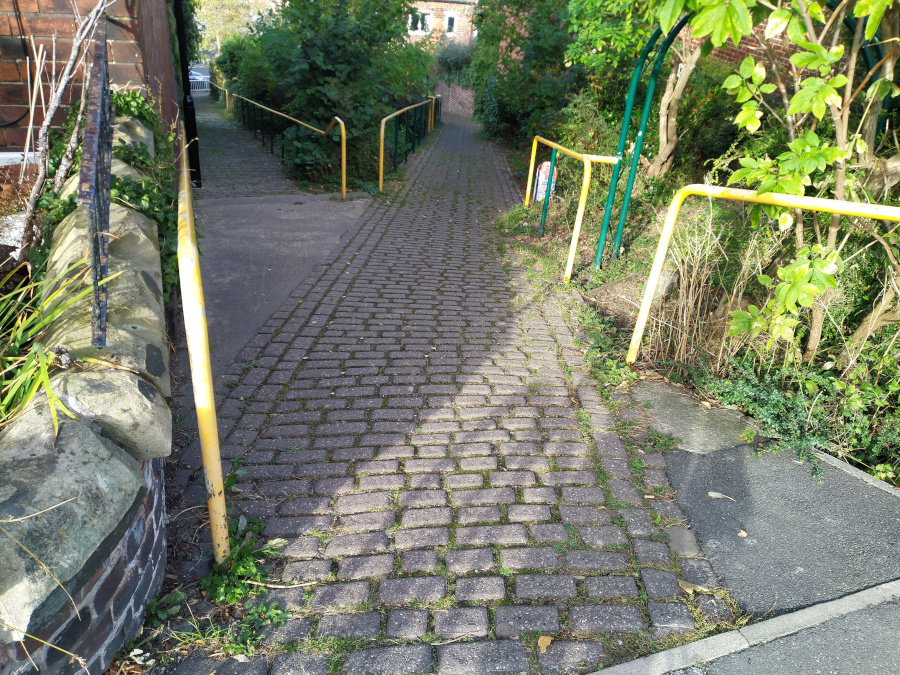
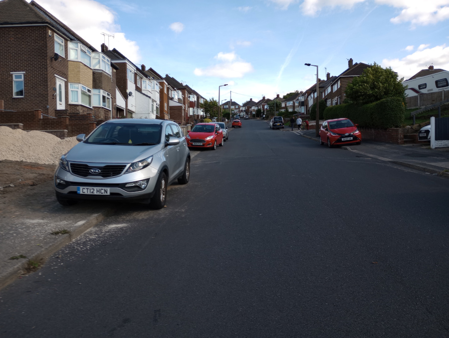
Cycling from the M1 underpass, there’s a short climb before you arrive at West Hill and its imposing opening. Despite what the Strava segment shows, the hill begins immediately and, within 20 metres, you’re already hitting around 20%. Once you’re past Whitley View Road, the initial bump mellows but still leaves you climbing at around the 10% mark for about 150m.

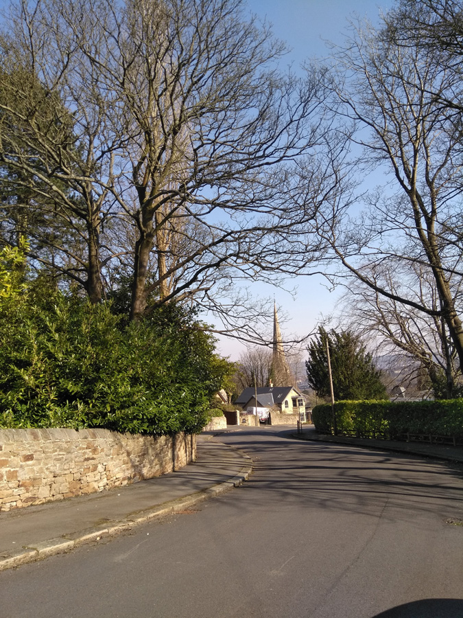
As West Hill begins to bend left, the gradient creeps up to the teens again, hitting 17% at the sharpest bit of the corner. The hardest bit is over now but you still have a short distance more to go but the gradient slowly peters out until you reach the top, just past the Hill Top Hotel.

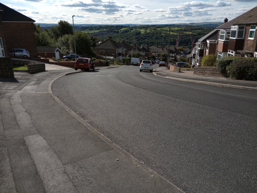
The climb is worth a quick blast if you’re in the area and once you do reach the top, roll round Richmond Park Road until you can descend Meadowhall Road, which is a nice, speedy reward for your efforts. Just be careful as the hill ends, slightly abruptly, at the massive roundabout for the Tinsley Viaduct junction and all the busy traffic that entails.

Found a hill to ride? ❤ Support the site!

Upper Valley Footpath

  • Upper Valley Footpath
  • Length: 185 feet (yes, it’s short)
  • Avg gradient: 21%
  • Peak gradient: 31%
  • Difficulty: 2/5
  • Likelihood of encountering unpleasant motor-vehicles: 0/5
  • Elevation gain: 40ft
  • Strava It won’t let me make one as it’s too short.

Want some ‘30% climb’ bragging rights?

While on the topic of gennels that you probably shouldn’t cycle up, I present to you the highly specific footpath between Upper Valley Road and Argyle Street, Meersbrook.

Facing the far more difficult Kent Road, this is its own unique challenge, with both a higher average and peak gradient than its neighbour. At only 184 feet long, it’s not time consuming, just make sure you do it when there isn’t someone coming down the path.

At the start you will see two paths, make sure that you take the one on the left, as I think the right-hand one has a few steps. It’s cobbled, so you can pretend you’re in Belgium as you begin the 10% opening. As the path bends slightly, the gradient is up to 20% and continues increasing as you climb. Keep the momentum, as you pass some little mosaic bollards and you briefly touch a 30% incline. Then, like that, you’re at the top.

You can now tell all your mates that you cycled up a 30% gradient, just don’t tell them how long it was.

Birks Wood Drive

  • Birks Wood Drive
  • Length: 0.44 miles
  • Avg gradient: 10.4%
  • Peak gradient: 16.9%
  • Difficulty: 2/5
  • Likelihood of encountering unpleasant motor-vehicles: 2/5
  • Elevation gain: 241ft
  • Strava

A sneaky suburban climb.

In an area rich with challenging climbs (Jawbone Hill, Wheel Lane and Burnt Hill Lane, for example) this is slightly lower profile. Nestled on a quiet suburban street, it packs enough of a punch to warrant its inclusion in previous Magnificent 7 hill climb competitions.

Turning off the unpleasant Langsett Road onto Birch House Avenue, you’re immediately into a double-figure gradient for a dead straight 0.1 miles. This first quarter of the ride is fairly representative of the hill’s feel as a whole, so just plod on.

There’s a little relent as the road bends right and the gradient briefly drops to around 6% before picking right up again as you turn left on to Birks Wood Drive itself. You’re now on the steepest section of the climb, on the sweeping right hand bend, hitting a peak of almost 17%.

A short distance on, the houses drop away, revealing a pleasant view of Oughtibridge and the valley below. Appreciate it quickly before a line of trees hides it once more and you approach the final bend. The Strava segment says it’s only 10% but it looks steeper, not least as you’ll be taking the inside lane. Once you’re around the bend, though, it’s only a few more metres until the apex, and the option of dropping back into Oughtibridge to tackle a few of the other great climbs in the area.

Ranmoor Crescent

  • Ranmmor Crescent
  • Length: 0.25 miles
  • Avg gradient: 9%   Peak gradient: 11.3%
  • Difficulty: 2/5
  • Likelihood of encountering unpleasant motor-vehicles: 1/5
  • Elevation gain: 124 ft
  • Strava

A short, little hill that featured in the 2017 Magnificent 7. Because the road has a broad S-shape, it’s not as steep as some of the other roads in the area.

You begin the climb at the crossroads with Ranmoor Road. The road curves around the the left as the gradient creeps to around 10-11%. This corner isn’t too challenging and soon the road bends back to the right, as you ride up the steepest section, which is only a brief 11.3%.

Admire the big houses here, as the road straightens out and drops to around 6%. You can see the junction with Ranmoor Cliffe Road in the distance, marked by a postbox on the right. As you take the left turn at the junction, you’re back to an 11% climb for the final short stretch until Watt Lane.

A pleasant enough climb but it’s not the challenge I was expecting. If you fancy something nearby that’s a bit trickier, try Ranmoor Park Road. A far straighter climb with fewer bends easing the gradient. I’ll save that one for a later date.

Earldom Road

  • Earldom Road
  • Length: 0.14 miles
  • Avg gradient: 13.6%   Peak gradient: 17.5%
  • Difficulty: 2/5 (only because it’s so short).
  • Likelihood of encountering unpleasant motor-vehicles: 1/5
  • Elevation gain: 101 ft 
  • Strava

This is a very short blast up a very steep hill. Hidden in the suburbs of Burngreave lies this surprising little spike that will give your legs a bit of a testing.

Earldom Road is only 0.14 miles long and you can see the apex from the outset so there’s no surprises in store. Just remember to get into the correct gear from the off, not like me on my last attempt where I thought I’d show off and blitz it up on a middle gear before I quickly ground to a halt, unable to pedal. Shamefaced, I dropped down to a low gear an made it to the top.

Earldom Road begins at about 6% as you join from Ellesmere Road. However, between the pub and Earldom Drive it ramps up to around 13%. Once you’re past that junction, the gradient steadily increases to 17.5% at the peak.

This hill is definitely a sprint, not a marathon, so just put your all into it and see how quickly you can get up it.

Smithy Wood Crescent

  • Smithy Wood Crescent
  • Length: 0.18 miles 
  • Avg gradient: 3% on the Strava segment but closer to 6%
  • Peak gradient: 10%
  • Difficulty: 2/5
  • Likelihood of encountering unpleasant motor-vehicles: 1/5
  • Strava

With its 180° curve, Smithy Wood Crescent is almost like one of the switchbacks on the Alpe d’Huez.  Almost.  This is a road I’d driven up many, many times and it always felt like it would be a formidable challenge to ride up on a bike. I was wrong.

First of all, in the hill’s defence, the Strava segment includes a bit of downhill at the start, which scuppers the average gradient.  It says 3% but I think it’s closer to 6% and it does reach double figures at the very end.

Whatever the actual stats, use the little downhill from Woodseats Road to get some speed then blast away as the road begins to climb for the first bend and then holds its steepness for a short straight stretch before you do that switchback.  Feeling like you’re cruising up the Alps, the gradient actually drops off a bit as you round the corner and approach the tree-lined final spike before joining Chesterfield Road. A quick blast.

I’m not sure why I thought this would be such a tough climb when it really isn’t much of a challenge at all.  I guess it’s included because ever since moving to the city, Smithy Wood Crescent felt like the typical Sheffield hill: short, steep and sitting in the middle of suburbia with no fanfare, when if it was anywhere else it would have a far more impressive reputation.

Meersbrook Park

  • Meersbook Park
  • Length: 0.3 miles
  • Avg gradient: 9.5%   Peak gradient: 20%
  • Difficulty: 2/5 (steep but not long)
  • Likelihood of encountering unpleasant motor-vehicles: 0/5
  • Strava

A very hilly park, a couple of miles south of the city centre. My introduction to Meersbrook Park was cycling downhill through it at great speed.  It made me wonder what it would be like to tackle it in the opposite direction. There are several routes – all looking steep – through the park but, for the sake of this, I did (with some extension) the Strava segment labelled ‘Meersbrook Grind’.

You’ll enter the park from the direction of Brooklyn Road and the house with the attractive bird mural by Faunagraphic.  The path starts easily enough as you pass the tennis courts on your right.  Looking left, through the trees, you can see what you’re about to tackle.  Follow the path and begin the climb in earnest.  It’s here the the Strava segment begins.

The path is smooth with a gentle curve and you can pretty much see where you’re headed the whole time but it is a bit unrelenting, hitting the peak gradients about halfway up. Different sources disagree about the steepest point of the hill, varying from 17% to almost 22%.  Whatever the reality, you get some idea of how steep the hill is from the angle of the houses in the photo.

If you can, glance behind you, as you climb higher and higher you get an ever more impressive panorama of Sheffield.  Eventually you’ll reach small play trail as the hill begins to peter out.  Shortly after, you’ll reach the 16th century Bishops House and the top of Meersbrook Park.  A short but sweet Sheffield hill climb.

Hunter House Road

  • Hunter House Road
  • Length: 0.24 miles
  • Avg gradient: 12%   Peak gradient: 16.2%
  • Difficulty: 2/5
  • Likelihood of encountering unpleasant motor-vehicles: 2/5 (oncoming vehicles could be tricky since it’s always parked up on both sides)
  • Strava

Featuring in one of the opening scenes of the Jodie Whittaker’s first Dr Who episode, Hunter House Road is a fairly quiet residential road, just off Hunters Bar, an area immortalised by the Arctic Monkeys on Fake Tales of San Francisco.  Your biggest challenge here are cars coming downhill, as both sides of the road are always parked up, leaving you little room to manoeuvre without losing your momentum.

The climb begins immediately, starting at 10% at the junction with Pinner Road, and the steepness steadily increases as you climb. You’ll hit a peak of 16.2% at house number 60, which is marked by a garage set back from the road.  You’re about two thirds of the way up the hill by now and beginning to feel the strain.

Hunter House Road in Dr Who: The Woman Who Fell to Earth BBC

Continue straight up until the road bends round to the left, at what looks like the hill’s apex.  However, looks can be deceiving and you’ll find that the climb continues round the corner.  A short distance more and the gradient drastically eases off just as you reach the Hunter Court flats.