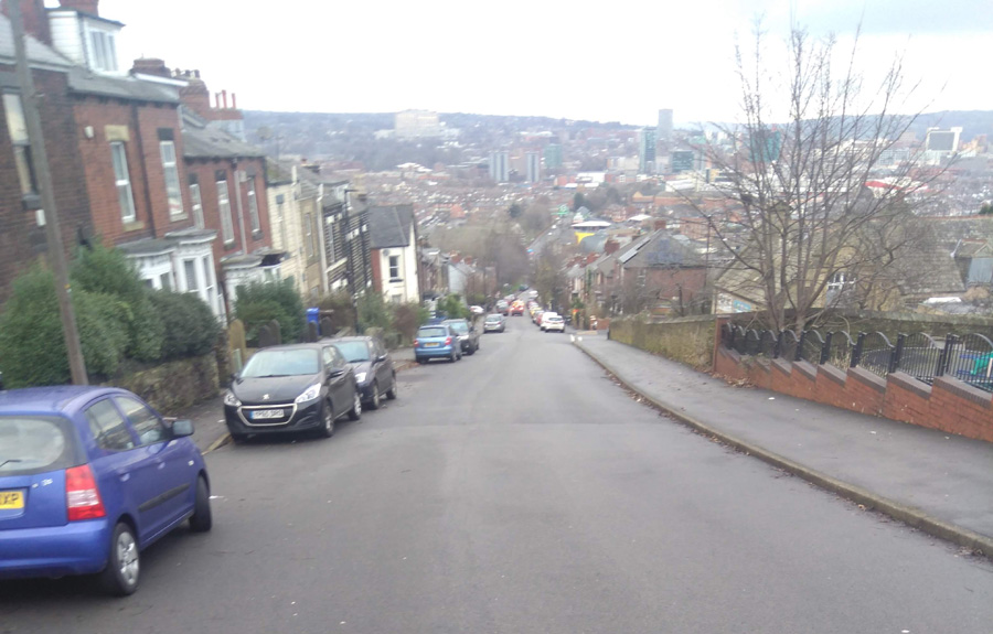
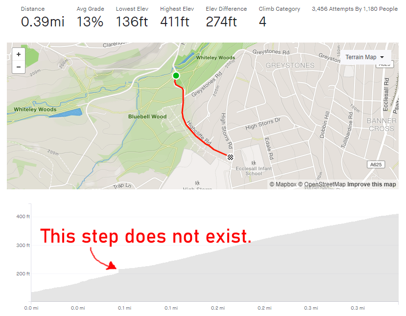
Tag: 0.25-0.5 miles

Cobnar Road

  • Cobnar Road
  • Length: 0.31 miles
  • Avg gradient: 13.5%   Peak gradient: 30ish%(!)*
  • Difficulty: 4/5
  • Likelihood of encountering unpleasant motor-vehicles: 1/5
  • Elevation gain: 226ft
  • Strava

An utterly deceptive beast.

Cobnar Road is a residential street that begins innocently enough but it is truly lulling you into a false sense of security.

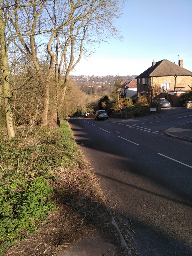
‘What’s going on here? This doesn’t seem too challenging and the gradient is only in single figures,’ you’ll think as you start the climb. Fair enough, Cobnar Road does begin unremarkably enough but what you might not notice straight away is how it gets progressively steeper, the further you progress.

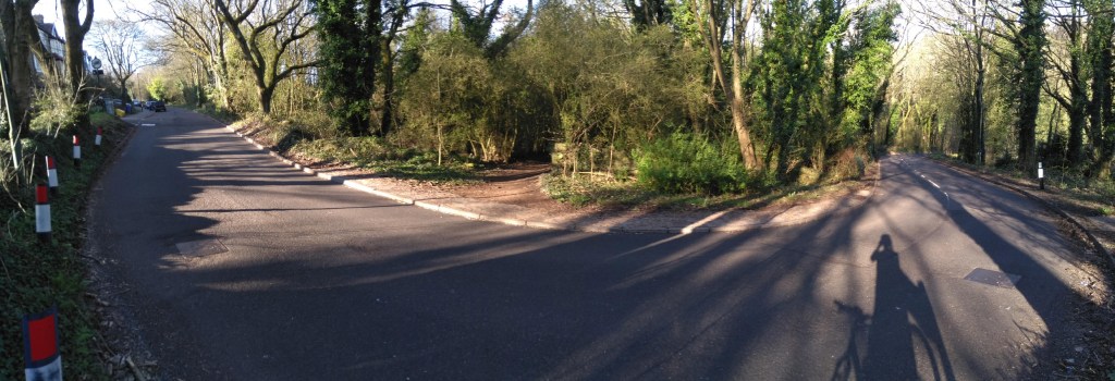
When you pass Bingham Road, you might sense that the hill has sneaked into low double figures but nothing noteworthy. However, another 50 metres or so, at the junction with Wellcar Road and the ‘dead end’ road sign, the gradient suddenly spikes into the teens. It’s at this point that you realise how the start of the climb tricked you.

Looking up, all you can see the rising tarmac and what looks like an impenetrable wall of trees. Dig in here as the worst is yet to come. Luckily the road is fairly wide and quiet, so you’ve got wiggle room and few hazards as you wind your way up the hill. This is where the fun starts.

Keep your momentum and switch on to what looks like a footpath (it’s not labelled as such, so you’re not breaking any rules by cycling up it). The narrow path (featuring a handy handrail) disappears around a blind corner – so you’ll have to hope that you’re not going to meet anyone walking down the opposite direction – and ramps up to a gradient of 17 – 18%. It’s only for 100m or so but, because of the path’s width and probably being slippery with leaves, there’s no room for mistakes. The last time I did it, I very nearly came off the tarmac and into the little ditch next to the path.

I seriously put Cobnar Road on a par with Hagg Hill, which is the bar against which I judge all other hills. So, if you get to the top without stopping, take a moment to get your breath back and congratulate yourself on, not only defeating such a cheeky beast of a climb but probably one of the most challenging hills in Sheffield.

*GPS coverage is a bit wonky under the trees at the top, with both Strava and Veloviewer saying an incline of almost 40%. That seems excessive but I wouldn’t be surprised if it does briefly break 30% at the end.

Conduit Road

  • Conduit Road
  • Length: 0.31 miles
  • Avg gradient: 9.7%   Peak gradient: 13.1%
  • Difficulty: 1/5
  • Likelihood of encountering unpleasant motor-vehicles: 2/5
  • Elevation gain: 68ft
  • Strava

A quick zip up a never too steep hill.

The hill begins in earnest, opening with a 12-13% incline as you pass the Management School. There is a gentle curve in the road and cars will probably be parked on both sides, so be aware of any oncoming vehicles. This is the steepest section and the gradient begins to reduce to single figures once you pass Redcar Road, ending at around 7% at the apex with School Road.

A little blast that won’t set the cycling world alight but a happy, little challenge none the less.

Ranmoor Park Road

  • Ranmoor Park Road
  • Length: 0.26 miles
  • Avg gradient: 10.3%   Peak gradient: 14%
  • Difficulty: 3/5
  • Likelihood of encountering unpleasant motor-vehicles: 1/5
  • Elevation gain: 142ft
  • Strava

It’s like the evil twin of the neighbouring Ranmoor Crescent. This road has all the climbing but none of the forgiving bends. It’s a straight up (literal and figurative) stinker.

You begin, just off Fulwood Road, by the Ranmoor Inn. As the road curves around the church you’re immediately into a dead straight 10% climb. To add insult to injury, as you slowly climb up the hill, the gradient gently increases, peaking out at about 14% as you pass Tapton Park Road. At this point, it definitely feels harder than you expect.

Keep on peddling and you’ll soon reach the sweeping left hand bend where the gradient drops down to 7.5%, and you pass Ranmoor Crescent. Grind on a short distance more until the end of the segment and then, when you reach it, ask yourself why you didn’t just ride up Ranmoor Crescent instead?

Highcliffe Road

  • Highcliffe Road
  • Length: 0.39 miles
  • Avg gradient: 13%   Peak gradient: 20.6%
  • Difficulty: 4/5
  • Likelihood of encountering unpleasant motor-vehicles: 5/5
  • Elevation gain: 274 ft
  • Strava

To cut to the chase, this is not a pleasant climb. There’s always parked cars reducing the carriageway width, it’s not picturesque and you’re going to encounter at least one obnoxious motorist on your way up. However, getting to the top is a great achievement.

I’ll be honest , I’ve only ridden up this hill twice: once at 9.30am on New Years Day, the other during the coronavirus lockdown. Both of those times I knew that it would be quiet enough to do without too much trouble. At any normal time however, you are going to get an impatient driver up your backside or attempt an uphill close pass. Be warned.

The climb begins as the road crosses the Porter Brook (much the same as Woodcliffe) and begins a steep S-bend. If you’re not on a road bike, you could avoid the carriageway and instead ride alongside the steps in the park. Be aware however, that’s actually steeper than the road itself. The Strava segment’s recording is a bit skew-whiff here but it probably averages about 10-12% on this bit, up to the junction with Greystones Road.

After that, the road can get clogged with parked cars, so there is nowhere for vehicles behind you to pass safely before the blind bend ahead. Be prepared to annoy some people as you slowly grind up this tree-lined section, which briefly pops above 20%.

On the approach to the Highcliffe Drive junction the gradient does begin to reduce slightly but still remains in double figures. You can, at last, see the end of the climb though. You’ll find that all the vehicles are now parked on the opposite side of the road, creating a bit of a slalom for the line of traffic coming downhill. This is the one time it might be acceptable to ride on the pavement, if only to avoid the dirty stares from people waiting in their cars. Shortly after this you’ll be at the top of the hill, so well done for that but there are so many nicer hills to climb in the city. Go and find one of them instead.

Ranmoor Crescent

  • Ranmmor Crescent
  • Length: 0.25 miles
  • Avg gradient: 9%   Peak gradient: 11.3%
  • Difficulty: 2/5
  • Likelihood of encountering unpleasant motor-vehicles: 1/5
  • Elevation gain: 124 ft
  • Strava

A short, little hill that featured in the 2017 Magnificent 7. Because the road has a broad S-shape, it’s not as steep as some of the other roads in the area.

You begin the climb at the crossroads with Ranmoor Road. The road curves around the the left as the gradient creeps to around 10-11%. This corner isn’t too challenging and soon the road bends back to the right, as you ride up the steepest section, which is only a brief 11.3%.

Admire the big houses here, as the road straightens out and drops to around 6%. You can see the junction with Ranmoor Cliffe Road in the distance, marked by a postbox on the right. As you take the left turn at the junction, you’re back to an 11% climb for the final short stretch until Watt Lane.

A pleasant enough climb but it’s not the challenge I was expecting. If you fancy something nearby that’s a bit trickier, try Ranmoor Park Road. A far straighter climb with fewer bends easing the gradient. I’ll save that one for a later date.

Wheel Lane & Coldwell Hill

  • Wheel Lane & Coldwell Hill
  • Length: 0.26 miles
  • Avg gradient: 15.4%   Peak gradient: 17.7%
  • Difficulty: 4/5
  • Likelihood of encountering unpleasant motor-vehicles: 1/5
  • Elevation gain: 217 ft 
  • Strava

A hidden gem of a hill climb, tucked away in the hills outside Oughtibridge. It’s just over a quarter of a mile long but look how close the average and peak gradients are.  That tells you that it’s a very unwavering climb all the way to the top.  And your reward for getting there?  Another hill.

As soon as you pass over the brook (which is liable to flooding in rainy periods) the hill begins with a little weave and a gradient of around 17%. Climb up this until the road makes a sharp right turn and a sign tells you that you’re now on Coldwell Hill. You’ll pass the first of the houses and a grit bin on your right, which makes you wonder how brave you’d have to be to drive up here in icy conditions.  It’s hard to believe but, at about 9%, this is the flattest section of the climb.

That’s soon forgotten however, as you wind round a dogleg bend with the steepest incline of the hill. As you curve past the row of quaint cottages you’ll be thinking that this must be it but you’re only about half way up. You’ve got a slightly straighter climb now but still averaging 15%. Shortly, the climb takes another sweep right and after a brief section of tree-lined road, another sign tells you that you’ve joined Jackey Lane for the final 600 ft.

Well done, you’ve just made it up one of my favourite Sheffield cycling climbs. From here, turn right and drop back into Oughtibridge or, if you fancy continuing the challenge, turn left onto Green Lane and tackle another mile or so of 8% out into the countryside.

Rails Road

  • Rails Road
  • Length: 0.42 miles 
  • Avg gradient: 8.5%   Peak gradient: 14.7%
  • Difficulty: 3/5
  • Likelihood of encountering unpleasant motor-vehicles: 2/5
  • Strava

If Lodge Lane is the bad cop, the Rails Road is the good cop. It might be slightly easier on you but you’re still in trouble.

Sitting practically opposite Lodge Lane, Rails Road takes you up towards Stannington and to the cusp of some absolutely beautiful country cycling. You’re immediately on a gradient of 5-7% as you pull away from the nasty main road and in the distance you can see your main target: the sweeping right-hand bend.  There’s not many distinguishing features to pick out from the fields either side of you at this point but passing a large gate on your left is the signal for the road to ramp up into double figures.

The gradient continues to increase the closer you get to the bend, hitting a peak of 14.7% (although Strava claims 18.2%) just before you turn. You’re on the left, so it’s not quite as tricky as it could be but you’re still feeling the effort. Once you’re around the bend, you’ll run alongside a trickling culvert, which feels like it’s taunting you on a hot, sweaty day and shortly pass a footpath on your left which is where the Strava segment incorrectly shows a short, flat section. Let’s be clear: there is no short, flat section on his hill. It’s a GPS anomaly.

There is a slight relent in steepness as you reach Woodbank Road (and a great alternative route to the countryside) but carry straight on. The ride is getting easier with every pedal now and soon flattens out as you pass farmhouses on either side of the road and a gorgeous view across the Rivelin Valley.

Lodge Lane, seen from Rails Road

You can either continue on to Stannington (after another bonus bump) and head out into the Peaks towards Dungworth and Bradfield, or zoom back down the hill and tackle Rails Road’s evil twin: Lodge Lane.

Myrtle Road

  • Myrtle Road
  • Length: 0.38 miles 
  • Avg gradient: 10%   Peak gradient: 16.5%
  • Difficulty: 2/5
  • Likelihood of encountering unpleasant motor-vehicles: 2/5
  • Strava

This hill climb starts just next to Heeley City Farm, a nice little slice of the countryside a couple of miles from the city centre. It’s worth popping into the Heely City Farm Café after tackling this hill for some tasty food or a hot chocolate.

Looking at the topography of Myrtle Road, it’s one of those weird streets that has a bizarre, almost unwaveringly consistent gradient. Hunter House Road and Blake Street being other examples. Strava says Myrtle Road peaks at 16.5% but while there is a little spike as you pass the Nursery at Heeley Bank Road, you are looking at a fairly solid 10% all the way up.

Begin the hill climb at the junction of Midhill Road, just after the railway bridge. There’s a row of houses on your left and what looks like a park on your right, actually contains a goat enclosure. Pick the right gear and pedal on.  Once you’re past Anns Road the hill seems to get steeper but I think that’s just because you’ve got houses and cars parked on both sides of the road, making it feel a bit more closed in and leaving you hoping that you’re not going to encounter a grumpy driver coming up or down the hill.

You’ll soon reach Heeley Bank Road and the aforementioned gradient spike. It’s not long to go now, so just dig in for that last blast before reaching the top at the site of the derelict pub and some nice views across the city. Now roll back down and pop to the farm café.

Meersbrook Park

  • Meersbook Park
  • Length: 0.3 miles
  • Avg gradient: 9.5%   Peak gradient: 20%
  • Difficulty: 2/5 (steep but not long)
  • Likelihood of encountering unpleasant motor-vehicles: 0/5
  • Strava

A very hilly park, a couple of miles south of the city centre. My introduction to Meersbrook Park was cycling downhill through it at great speed.  It made me wonder what it would be like to tackle it in the opposite direction. There are several routes – all looking steep – through the park but, for the sake of this, I did (with some extension) the Strava segment labelled ‘Meersbrook Grind’.

You’ll enter the park from the direction of Brooklyn Road and the house with the attractive bird mural by Faunagraphic.  The path starts easily enough as you pass the tennis courts on your right.  Looking left, through the trees, you can see what you’re about to tackle.  Follow the path and begin the climb in earnest.  It’s here the the Strava segment begins.

The path is smooth with a gentle curve and you can pretty much see where you’re headed the whole time but it is a bit unrelenting, hitting the peak gradients about halfway up. Different sources disagree about the steepest point of the hill, varying from 17% to almost 22%.  Whatever the reality, you get some idea of how steep the hill is from the angle of the houses in the photo.

If you can, glance behind you, as you climb higher and higher you get an ever more impressive panorama of Sheffield.  Eventually you’ll reach small play trail as the hill begins to peter out.  Shortly after, you’ll reach the 16th century Bishops House and the top of Meersbrook Park.  A short but sweet Sheffield hill climb.