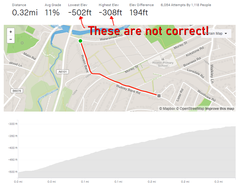
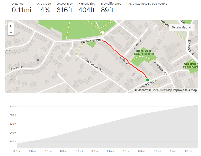
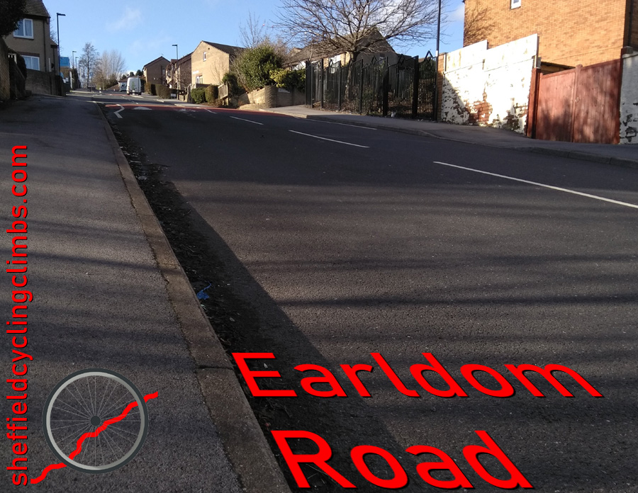
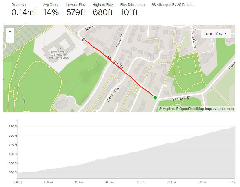
Tag: 10%-15%

Earldom Road

  • Earldom Road
  • Length: 0.14 miles
  • Avg gradient: 13.6%   Peak gradient: 17.5%
  • Difficulty: 2/5 (only because it’s so short).
  • Likelihood of encountering unpleasant motor-vehicles: 1/5
  • Elevation gain: 101 ft 
  • Strava

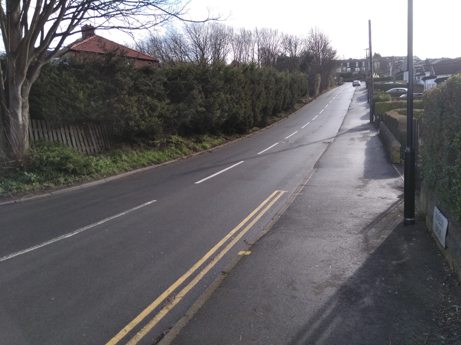
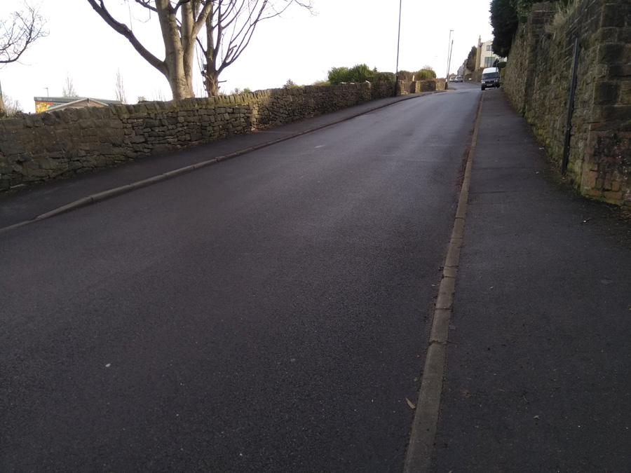
This is a very short blast up a very steep hill. Hidden in the suburbs of Burngreave lies this surprising little spike that will give your legs a bit of a testing.

Earldom Road is only 0.14 miles long and you can see the apex from the outset so there’s no surprises in store. Just remember to get into the correct gear from the off, not like me on my last attempt where I thought I’d show off and blitz it up on a middle gear before I quickly ground to a halt, unable to pedal. Shamefaced, I dropped down to a low gear an made it to the top.

Earldom Road begins at about 6% as you join from Ellesmere Road. However, between the pub and Earldom Drive it ramps up to around 13%. Once you’re past that junction, the gradient steadily increases to 17.5% at the peak.

This hill is definitely a sprint, not a marathon, so just put your all into it and see how quickly you can get up it.

Rivelin Bank & Walkley Bank Road

  • Rivelin Bank & Walkley Bank Road
  • Length: 0.32 miles
  • Avg gradient: 11.3%   Peak gradient: 14.9%
  • Difficulty: 3/5
  • Likelihood of encountering unpleasant motor-vehicles: 2/5
  • Elevation gain: 194 ft
  • Strava

The first time I tackled this climb I didn’t really know where I was going and thought this might have been a more direct route home. I might have been correct about it being more direct but it certainly wasn’t flatter.

Rivelin Bank’s gradient is very quickly into double figures with an average of 13% until the bend to the left and the junction with Racker Way. It’s a dead straight section, so it’s all about putting your head down and grinding. The first time I did the hill and its steepness took me by surprise, I had to take a turn around an apartment’s parking lot about half way up, just to get my breath back without having to actually stop pedaling.

The approach to the bend is the steepest section and, once you’re around it, the gradient does ease off, dropping to around 10.5% for the second half of the climb. You’re now on Walkley Bank Road, with the allotments on your left and a high wall on your right. Once you pass the junction of Hawthorne Road the steepness begins to peter out, until you trundle to the apex at Walkley Bank Close.

This was by no means the end of my route home and, as you’ll find if you explore Walkley, by no means the only challenging hill in the area.

Loxley to Kirk Edge

  • Loxley to Kirk Edge
  • Length: 1 mile
  • Avg gradient: 10.4%   Peak gradient: 15.9%
  • Difficulty: 3/5
  • Likelihood of encountering unpleasant motor-vehicles: 1/5
  • Strava

I was introduced to this road, which featured in the 2017 Magnificent 7, when out with my pizza-and-beer cycling club. The usual ride leader wasn’t able to come so the ride was led by one of the riders who likes to do hill reps. He zoomed up here, the rest of us puffed and panted after him.

If you’re heading from the city, you’ll have probably already climbed almost 250ft up Loxley Road before you reach West Lane and the start of this hill. That’s not too much of challenge but it is a bit of a slog, so make sure you’re not blitzing it up there and not leaving enough in the tank for this climb.

Turning right, on to West Lane, you’re immediately on a 10-11% gradient for the first, dead-straight, 0.3 miles. Just dig in here as the road will eventually get a bit more interesting. Soon enough, you’ll reach the first bend, with a farmhouse on the left, and the one of the the climb’s steepest sections, at 15.9%, shortly after. At the halfway mark, as Meyers Lane joins from the right, the gradient reduces for a short distance before ramping right up again as you pass Green End Farm, and on into the hamlet of Holdsworth.

The road wiggles through farmhouses, barns, and the sounds and smells of the countryside and you’ll soon have fields on either side.  With 0.2 miles to go, the road has a bend to the right, then a straight section with an incline of around 7% (my three sources all disagree about the exact figure), followed by this climb’s sting-in-the-tail: a little dog-leg of about 15.9%, the end of which is marked by a telegraph pole.

Once you reach the pole, pootle to the end of the road and turn left towards Bradfield or right for an extremely enjoyable descent into Worrall and Wadsley.

Roper Hill

  • Roper Hill
  • Length: 0.23 miles 
  • Avg gradient: 10.4%   Peak gradient: 15.2%
  • Difficulty: 3/5
  • Likelihood of encountering unpleasant motor-vehicles: 1/5
  • Strava

I came across this climb when I was route planning and wanted the most direct way from Redmires Reservoir to Ringinglow Road. I didn’t realise until riding that near the beginning of that direct route lay Roper Hill.

It’s less than a quarter of a mile long but, for the unsuspecting rider, its a kick in the teeth. However, I’m sure it’s a joy for hill climbers and perfect for your hill reps. Indeed, last time I rode here there was a club doing reps, with one of their number playing Andy Williams’ It’s The Most Wonderful Time of the Year to motivate them uphill.

For the rest of us mortals though, prepare to dig in for a short, sharp blast. Roper Hill starts innocently enough as you turn in from Brown Hills Lane but very quickly ramps to about 8% up as you approach the first bend. The gradient only increases as you climb up the brief, straight section to the switchback. Luckily, you’re on the left, so the turn is not as punishing as it could be.

As you climb the next chunk, Roper Hill is holding a steady 11% but take a moment to glance to your right and appreciate the beautiful landscape beneath you. Let that, and the sight of the next bend at the hill’s apex (unfortunately also the steepest section at 15.2%), spur your legs on and you’ll soon be at the top.

From here, you’ve got a pleasant mile and a half ride, past the alpaca farm, to join Ringinglow Road and the options that presents.

Myrtle Road

  • Myrtle Road
  • Length: 0.38 miles 
  • Avg gradient: 10%   Peak gradient: 16.5%
  • Difficulty: 2/5
  • Likelihood of encountering unpleasant motor-vehicles: 2/5
  • Strava

This hill climb starts just next to Heeley City Farm, a nice little slice of the countryside a couple of miles from the city centre. It’s worth popping into the Heely City Farm Café after tackling this hill for some tasty food or a hot chocolate.

Looking at the topography of Myrtle Road, it’s one of those weird streets that has a bizarre, almost unwaveringly consistent gradient. Hunter House Road and Blake Street being other examples. Strava says Myrtle Road peaks at 16.5% but while there is a little spike as you pass the Nursery at Heeley Bank Road, you are looking at a fairly solid 10% all the way up.

Begin the hill climb at the junction of Midhill Road, just after the railway bridge. There’s a row of houses on your left and what looks like a park on your right, actually contains a goat enclosure. Pick the right gear and pedal on.  Once you’re past Anns Road the hill seems to get steeper but I think that’s just because you’ve got houses and cars parked on both sides of the road, making it feel a bit more closed in and leaving you hoping that you’re not going to encounter a grumpy driver coming up or down the hill.

You’ll soon reach Heeley Bank Road and the aforementioned gradient spike. It’s not long to go now, so just dig in for that last blast before reaching the top at the site of the derelict pub and some nice views across the city. Now roll back down and pop to the farm café.

Blake Street

  • Blake Street
  • Length: 0.11 miles
  • Avg gradient: 14%   Peak gradient: 17.4%
  • Difficulty: 3/5
  • Likelihood of encountering unpleasant motor-vehicles: 2/5
  • Strava

Look on any list of Sheffield’s steepest hills and Blake Street will be in there, so it was with some trepidation that I finally got around to tackling this one. Any road that has had a handrail for pedestrians, you know is going to be steep and Blake Street has one running its entire length.

You’ll feel the hill’s impact from the the moment you put your pedal down to begin the unwavering climb.  However, you’ll want to make sure that you’re in the right gear from the off, not do what I did and end up losing any momentum I had as I attempted to drop into my lower gears too late while trying to start climbing.  From there it’s just head down, breathe deep and push up as fast as you can.  You’ll quickly understand why this road features in many hill climb races.

Blake Street is a sprint though, not a marathon and, despite its reputation, I found it easier than I was expecting.  Simply put, it’s not very long, so it’s over relatively quickly.  I guess it’s a far different story if you’re a hill climb racer but if, like me, you just want to get to the top without worrying too much about times, it is perfectly doable.  Definitely one to tick off a list but if you’re looking for more of a challenge, give Hagg Hill a go: similar in character but with a higher gradient and slightly longer.

Blake Street in The Full Monty.

Hunter House Road

  • Hunter House Road
  • Length: 0.24 miles
  • Avg gradient: 12%   Peak gradient: 16.2%
  • Difficulty: 2/5
  • Likelihood of encountering unpleasant motor-vehicles: 2/5 (oncoming vehicles could be tricky since it’s always parked up on both sides)
  • Strava

Featuring in one of the opening scenes of the Jodie Whittaker’s first Dr Who episode, Hunter House Road is a fairly quiet residential road, just off Hunters Bar, an area immortalised by the Arctic Monkeys on Fake Tales of San Francisco.  Your biggest challenge here are cars coming downhill, as both sides of the road are always parked up, leaving you little room to manoeuvre without losing your momentum.

The climb begins immediately, starting at 10% at the junction with Pinner Road, and the steepness steadily increases as you climb. You’ll hit a peak of 16.2% at house number 60, which is marked by a garage set back from the road.  You’re about two thirds of the way up the hill by now and beginning to feel the strain.

Hunter House Road in Dr Who: The Woman Who Fell to Earth BBC

Continue straight up until the road bends round to the left, at what looks like the hill’s apex.  However, looks can be deceiving and you’ll find that the climb continues round the corner.  A short distance more and the gradient drastically eases off just as you reach the Hunter Court flats.